
Multisensor Data Fusion Optimizes Traffic Flow and Intersection Safety, Delivering Cost and Time Savings
Digital-Twin Framework Provides Real-Time Visibility Into Traffic Conditions

We have all been there: stopped at a red light at an empty intersection or narrowly avoiding a collision after a driver runs a red light.
Researchers at the National Laboratory of the Rockies (NLR) are working to reduce such risks by improving how intersections “see” and respond to real-time traffic conditions. Their approach combines infrastructure-based cooperative perception, multisensor data fusion, and data-driven analytics to enhance safety and operational efficiency at signalized intersections—reducing delays, saving time, and lowering transportation costs.
The need for these improvements is significant. Traffic crashes and congestion impose major costs in the United States, with more than 40,000 fatalities and approximately $300 billion in economic losses each year. Intersections account for a disproportionate share of the problem, contributing to nearly one-quarter of all traffic fatalities and half of all traffic injuries.
More efficient signal operations could also generate substantial savings. According to the Federal Highway Administration, optimizing signal timing can reduce delays by 15%–40% and fuel consumption by up to 10%, depending on conditions.
“A substantial share of crashes and excess fuel consumption are associated with intersections,” said Stan Young, an NLR advanced mobility specialist. “It’s a persistent challenge that, until recently, was difficult to solve.”
A Digital Twin of Intersection Activity
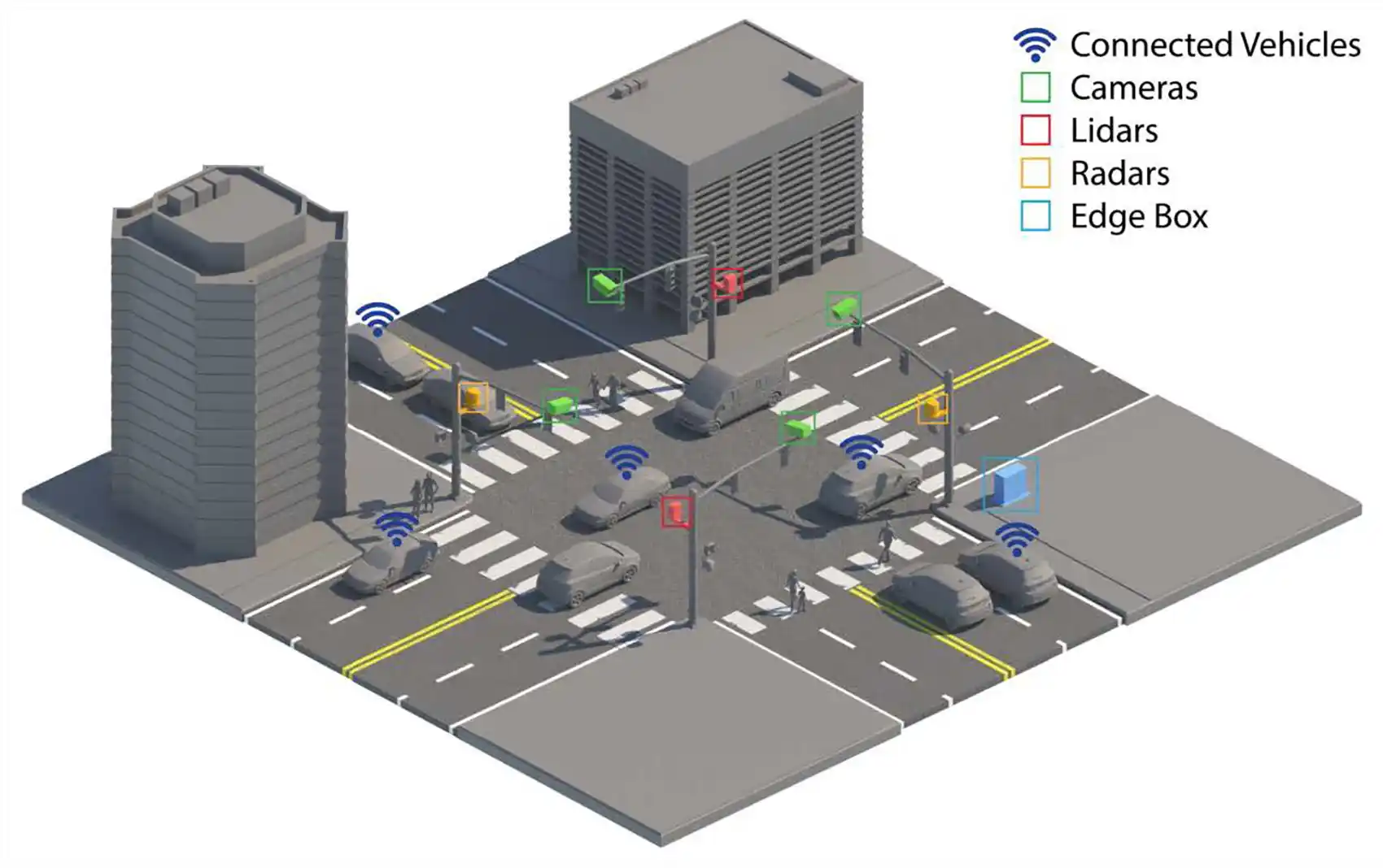
At the center of this effort is IPC-Fusion, an open-source toolkit—now available for licensing—that integrates data from sensors mounted on traffic lights and nearby buildings, along with connected-vehicle data, into a unified, digital representation of intersection activity. Following successful demonstration and validation efforts, NLR is in discussions with a major traffic solutions provider to license the technology for broader adoption.
The infrastructure perception and control (IPC) framework fuses data from cameras, radar, lidar, and connected vehicles to create a high-fidelity digital twin that provides a comprehensive, blind-spot-free view of vehicle and pedestrian movements.
The goal is to enable applications such as traffic signal performance monitoring, signal timing optimization, real-time adaptive signal control, congestion mitigation, roadway and pedestrian safety analysis, and transportation energy modeling.
“With a real-time, multisensor view of intersection activity, intelligent infrastructure can improve traffic flow and reduce crashes in the near term while laying the foundation for automated mobility, where vehicles and infrastructure share a common understanding of road conditions,” Young said.
In practice, this would enable a traffic signal system to respond more dynamically to real-time conditions. For example, the system could detect a single waiting vehicle at an otherwise empty intersection and adjust signal timing accordingly or extend pedestrian crossing times when someone needs more time to cross safely. Additionally, it could identify unusually high traffic associated with special events, emergency vehicles, or evacuations and adapt signal timing to accommodate changing traffic patterns. It could also detect patterns of harsh braking and frequent red-light running, providing valuable safety insights to help transportation agencies identify and address high-risk locations.
These operational improvements can also reduce fuel waste caused by unnecessary idling and stop-and-go traffic, lowering vehicle operating costs for drivers while helping agencies optimize intersection performance without major capital investments.
The IPC-Fusion approach is particularly valuable for traffic management entities, including municipalities and state and local departments of transportation, seeking vendor-agnostic, sensor-agnostic traffic monitoring solutions that support multiple downstream applications. By leveraging existing detection technologies and enabling future sensor upgrades, it provides long-term flexibility while avoiding technology and vendor lock-in.
Overcoming Integration Barriers
This work is supported by NLR’s Infrastructure Perception and Control Laboratory, where researchers integrate advanced sensing, digital twins, and optimization techniques to improve the safety, performance, and efficiency of intelligent transportation systems.
“Fusing object-level information from diverse sources in real time is a challenging mathematical and computational endeavor,” said Rimple Sandhu, an NLR computational scientist. “Our goal was to build a multisensor data fusion framework for creating a real-time digital twin of intersection traffic on edge devices with limited processing power—able to operate across different sensor types, detect a wide range of objects, and connect through infrastructure-to-everything communications with high reliability and accuracy.”
A key challenge is integration. Hardware manufacturers, such as producers of cameras, radar, and lidar systems, and the software developers who process the resulting data often operate in silos, relying on rigid data pipelines designed for specific end uses, making cross-platform data fusion difficult.
At the same time, connected and automated vehicle technology developments are often proprietary.
IPC-Fusion leverages artificial intelligence (AI), machine learning, and classical statistical methods to process and reconcile diverse data streams into a unified model of intersection behavior. Its standardized data interfaces minimize vendor lock-in and simplify the integration of emerging sensing technologies for infrastructure intelligence.
From Research to Real-World Intersections
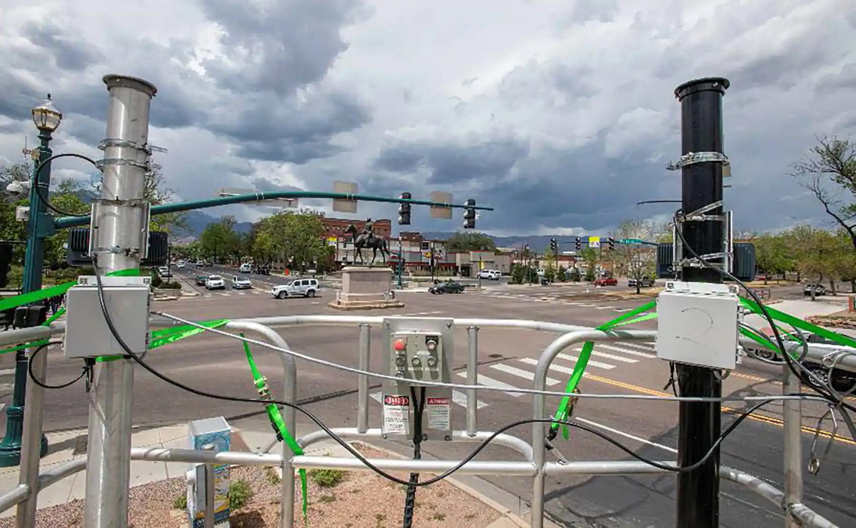
NLR researchers validated the system through multiple demonstrations in Colorado Springs and Lakewood, Colorado, where a variety of sensor types were installed at operational intersections.
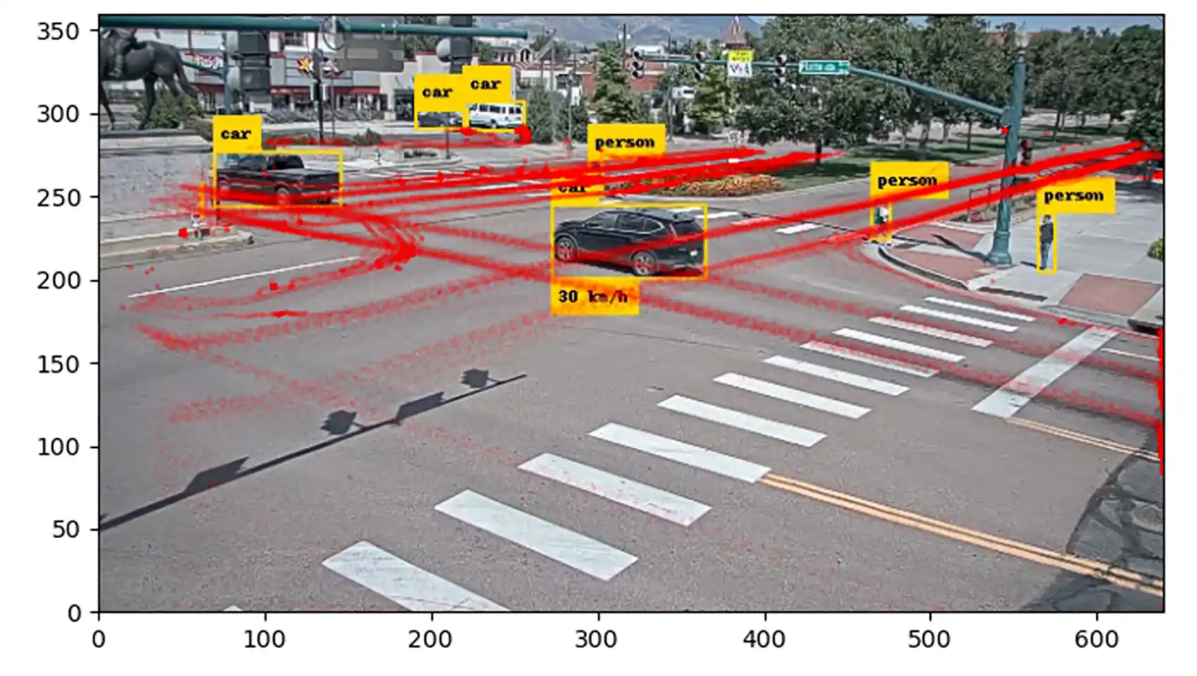
“The system took inputs from three modern sensor types—lidar, radar, and AI-enabled video cameras—aligned their outputs within a common reference frame, and fused the detections into a unified operational picture of vehicles, pedestrians, and cyclists moving through the intersection,” Young said. “Each road user 'track' integrated information from multiple sensors to provide not only a highly accurate trace of location, but also a measure of detection confidence and certainty—an important improvement over previous approaches.”
The results show that the digital twin framework can support a range of emerging intersection applications, including safety-focused signaling, signal optimization, improved traffic flow, efficient approach and departure, curb management, and future infrastructure-to-vehicle communication. These capabilities can also reduce the time and cost required to evaluate, monitor, and optimize traffic operations across large transportation networks.
Building on these demonstrations, NLR is now working with partners to expand and scale the solution more broadly.
In parallel, NLR developed a repository of object-level trajectory data derived from roadway activity to support continued research in multisensor data fusion.
“To my knowledge, this is one of the only publicly available field-collected datasets that includes both infrastructure sensor and connected vehicle data,” Sandhu said.
Tracking Traffic Movements at Scale
Beyond developing digital twins of intersection activity, researchers also created a computationally efficient and automated method to classify turning movements using connected-vehicle trajectory data. The approach uses spatial filtering, heading derivation, and clustering to classify turning movements, providing an efficient alternative to complex map-matching, which can be computationally intensive and prone to errors at complex intersections.
Validated at 10 intersections with diverse geometries and traffic conditions, the method reliably captures real-world traffic movement patterns. The resulting data enables transportation agencies to evaluate signal performance, detect operational issues, assess safety risks, and analyze energy impacts across transportation networks.
“Real-world validations show these approaches can scale, supporting accurate tracking and reliable insight into traffic patterns under real-world conditions,” Sandhu added.
Toward Connected and Intelligent Infrastructure
While these technologies are already being demonstrated to improve traffic monitoring and intersection performance, researchers see broader opportunities ahead as connected and automated vehicles become more common.
By combining infrastructure and vehicle data into a shared, real-time view of traffic conditions, intelligent infrastructure could improve situational awareness, support safer operations for all road users, and help transportation agencies manage increasingly complex traffic networks more efficiently. Continuous, data-driven insight into intersection operations can also help agencies reduce operating costs, prioritize maintenance and capital investments, and maximize the value of existing transportation infrastructure.
Together, these demonstrations showcased scalable methods for vehicle and pedestrian tracking, traffic pattern analysis, and digital-twin development, laying the groundwork for next-generation intelligent transportation systems.
Expanding AI and Data Capabilities to Other Transportation Challenges
The AI, data fusion, and digital infrastructure capabilities developed through this work are also being applied to other transportation challenges.
One of the most difficult data challenges facing the nation’s roadway networks is fusing information from multiple, disparate agency data sources that track roadway maintenance, construction, and road closures, and combining that information in real-time with emergency response activities. Doing so could provide travelers—and increasingly, automated vehicles—with timely information on roadway hazards and areas to avoid. Using modern AI techniques, NLR is demonstrating the transformation and normalization of these disparate, often manually generated data sources into standardized, machine-readable message streams, allowing for rapid dissemination.
AI, in the form of large language models, is also being used to assemble a national database of microtransit operations. These small fleets, often consisting of minivan-sized vehicles, are managed and dispatched through smartphone applications similar to ride-hailing platforms such as Uber and Lyft. Microtransit services have grown organically across the nation, but no central information system tracks their proliferation and impacts or provides travelers with a comprehensive way to locate and learn about them. Using large language models and collaborating with local operators, NLR is developing a national-level dashboard to discover and characterize these systems while allowing local experts to edit and customize the information.
In another application, NLR is using AI-enabled sentiment analysis to track user responses to robotaxis, assess attitudes toward traveler assistance at major airports, and identify differences in user satisfaction between frequent and infrequent transit riders, particularly at airports.
Learn more about the National Laboratory of the Rockies’ Infrastructure Perception and Control Laboratory. And sign up for our transportation and mobility research newsletter to stay current on the latest news.
Last Updated April 28, 2026